
This week, I managed to pique the curiosity of my husband also, and we took a road trip to solve the mystery.
It was a short trip of about fifty miles from downtown Jacksonville. We read that it was near Waverly, GA. We passed a big sign indicating our road was in one mile, then we passed the half mile, and finally, another huge sign showing where to turn. These gigantic and numerous signs seemed to indicate that this was a very significant place.
The two lane road we turned onto was deserted and lined with woods, dilapidated mobile homes, and old houses with trash in the yards. So far, this road did not seem significant. In about four miles, we came to a little church with a sign out front. We stopped, hoping to find someone who could tell us about the church and what it might have to do with the I-95 road sign. The church was locked and deserted. We'd get no information here.
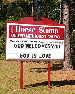
The sign let us know we were in the right place.
The church, however, was locked and deserted.

The church
We drove on thinking Waverly would turn up soon. We passed a long drive leading to a plantation sized inn called, of course, the Horse Stamp Inn.

The sign was designed to look like a postage stamp. We stopped hoping to ask a few questions at the inn, but the gate was locked, no one was in sight and we couldn't get in. To quote Alice in Wonderland this was getting "curiouser and curiouser."
Finally, we came to an intersection with a Minute Mart. Now we could ask our questions.
Jay, a very friendly man, was at the counter. He told us that the name of the road dates back to the Civil War. At a camp near the road, soldiers used to have their horses stamp down the grass and weeds, so the soldiers could have their church services in a flattened place. So, maybe "horse stamp" isn't the name of a church building, but the name of the flattened grass "church" stamped out by the horses. Who knows? It doesn't seem like an event with enough significance to be passed on since the Civil War.
The explanation does and did sound like a myth to me. This was especially so since we learned from the Internet that the 20 mile road was paved in 2008. Internet documents show the road was once called Ella Park Church Road, raising further doubt about the Civil War story.
We also learned the Horse Stamp Inn is considered quite elegant. I think we were there on a wrong day or we needed to give advance notice of our arrival. As for Waverly, it was only the Minute Mart and a post office just in front of it. People do live in the woods near the Mart, but it could hardly be called a town, maybe a community. Basically, our road trip was a bust, but definitely interesting, and it was a beautiful October day.

The Waverly, GA postoffice with the Minute Mart
across a parking lot behind it.

